Here’s a link to a graduate thesis for the Harvard School of Design written by Master’s candidate Anne Burns in 1988. The thesis, while clearly a scholarly exercise, presents a great overview of the issues that were facing Roxbury and Highland Park nearly 25 years ago. It should be required reading for anyone who wants to discuss redevelopment in the area today, especially for the redevelopments scheduled at Bartlett Yard and Jackson Square.
The thesis starts out with her reasons for choosing Highland Park as a subject area, a brief but well-done history, and then jumps right into some of the issues the neighborhood was facing in the mid-80s. In some ways, things couldn’t be more different, and in others they haven’t changed at all.
The biggest difference is that at the time, a huge proportion of Highland Park was still distressed but there was finally a significant amount of renovation happening. While we still have a handful of vacant buildings and there are many occupied buildings that could use a little sprucing up, I think it’s fair to say that the neighborhood has long since recovered from the worst of the population decline of the late 60s and early 70s.
The similarities are perhaps more striking. Ms. Burns notes that residents of the neighborhood tend to have a much higher opinion of the area than outsiders. She notes that despite this, people who do not live here were in charge of decisions that would have huge impacts on those who did. And she discusses some of the reasons for this from an architectural point of view, discussing the way our community presented itself to the outside world from those places that the outside world would most likely see it: along Columbus Avenue, Washington Streeet, from Roxbury Crossing and Jackson Square T stations, and along Malcolm X Boulevard.
She also notes that the residents were cautiously optimistic about the amount of redevelopment and new development taking place at the time. They wanted something that felt unified, cohesive, and well-planned. They feared piecemeal development that didn’t fit the character of the neighborhood, such as large public housing towers being dropped onto sites right next to one and two-family houses. They also wanted to maintain and celebrate our neighborhood’s many historical sites. Hopefully all of this sounds familiar to those of us who are engaged in shaping Highland Park today.
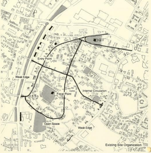
After the discussion of why and how she will look at the neighborhood for redevelopment, the thesis dives into a GIS exercise. Given the primitive nature of GIS software at the time, this is a pretty impressive undertaking, with page after page of detailed maps showing historic buildings, rowhouses, institutional structures, primary and secondary roads and traffic patterns, and vacant land.
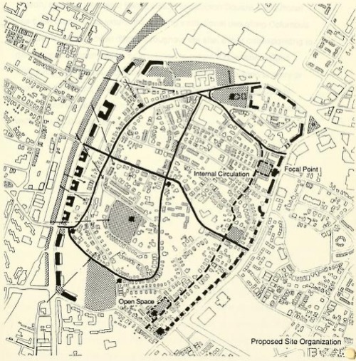
She notes historic areas and viewpoints, and denotes the “spheres of influence” of the First Church and the Standpipe. After all of this, she makes a development proposal focusing on new development in 5 key areas: the area where the mosque now sits, the area around the corner of Shawmut and Malcolm X, the Bartlett Yards area, the cluster of vacant lots around Thornton and Valentine, and the empty space along Columbus (including the RCC parking lots).
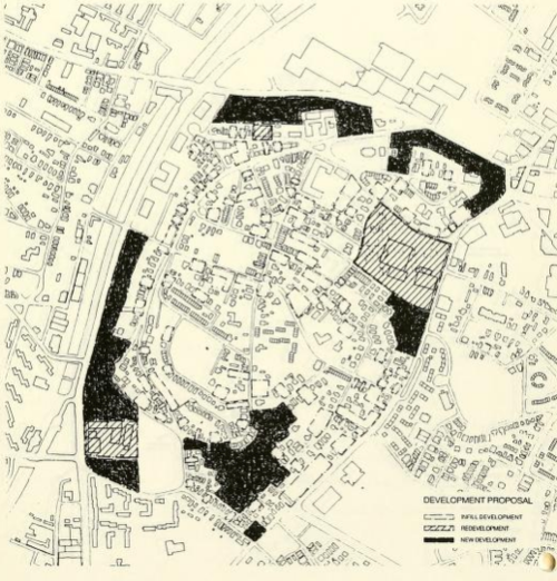
She takes great care to propose developments that will unify the neighborhood, siting larger institutional uses as a “hard edge” along Columbus and preferring residential-scale 1-3 families on Washington and in the Thornton Street parcel. I won’t go into full detail here, but it’s a fascinating read and many of her analyses and decisions still hold up almost 25 years later.
Sadly, many of these parcels are still vacant, but as we continue to discuss what should go where, I’d suggest taking a fresh look at this document. There is a lot we could bring into the current planning process.