map

1775 view of Roxbury from Beacon Hill by Jason Turgeon

First post in a long while, but I couldn't miss this.

The Boston Globe has a nice write-up of the Boston Public Library's "We are One" exhibition that features 4 watercolors painted by Lt. Richard Williams of the British Army during the Siege of Boston. One of the paintings shows Fort Hill, including the meeting house (First Church in Eliot Square) and "Rebel Lines."

The website has a zoomable version of the painting, but you should really go down to the BPL to check it out for yourself if you can. 

A screen grab of the Roxbury portion of the watercolor series. #6 is the First Church in Eliot Square, and #7 is the "Rebel Lines," showing the upper and lower forts (visible only as a continuous set of walls) that guarded the road to Cambridge and …

A screen grab of the Roxbury portion of the watercolor series. #6 is the First Church in Eliot Square, and #7 is the "Rebel Lines," showing the upper and lower forts (visible only as a continuous set of walls) that guarded the road to Cambridge and Dedham.

Here's the full info, cribbed from the BPL site:

 We Are One: Mapping America’s Road from Revolution to Independence

Central Library in Copley Square (McKim Exhibition Hall)

May 2 to November 29, 2015
Monday–Thursday: 10 a.m.–7 p.m., Friday–Saturday:10 a.m.–5 p.m.,
Sunday: 1–5 p.m.

Featuring 60 maps and 40 prints, paintings and objects, this major gallery exhibition traces the American story from the French and Indian War to the creation of a new national government and the founding of Washington, D.C. as its home.

Organized by the Norman B. Leventhal Map Center, We Are One features treasures from the Boston Public Library, the British Library, Library of Congress, and others. Highlights include rare and historically significant items that have not been previously exhibited. Visit the exhibition web pageto view an online exhibition, browse Revolutionary War era maps, and explore related resources.

Exhibition Tours: Thursdays and Saturdays at 2 p.m. Free tours of the We Are One exhibition are offered twice weekly by volunteer tour guides (through October 15th). No reservation required for parties smaller than 8 people. A smart phone tour of the exhibition is available at www.bpl.org/mobiletours.

The Story of our Mile Markers, as told by the Globe by Jason Turgeon

Last week, the Globe ran a nice story on the history of the mile markers in Boston. Our neighborhood is fortunate enough to have two of these from the 1700's, the Parting Stone in Eliot Square and the 3-mile marker just down Centre across from Gardner.  Most of these were installed by Paul Dudley, one of Roxbury's many famous Dudleys.

The story also included this map showing the location of all the mile markers around Boston.  If you've never taken the time to stop and visit the Parting Stone or Mile Marker 3, make sure you do next time you're walking around the neighborhood!


The Millennium Trail by Jason Turgeon

A while back I heard about a ‘zine that covered historical Roxbury sites as a self-guided tour.  Intrigued, I tracked down the principal author, local artist and an instructor at the RCC Upward Bound program Neil Horsky.  Neil is allowing me to post PDFs of his project here for wider distribution.

Here’s Neil’s description of the project, which he completed with the help of four local youths as part of his work with Upward Bound:

The Millennium Trail was a 1990s failed federal program to create historic trails through US cities and towns, including in Roxbury where only one plaque was installed.

Four high school students in RCC’s Upward Bound 2012 summer program investigated historic sites in Roxbury through community exploration, online research, and collaborative arts exercises.  We considered how these sites and stories are relevant today in the New Millennium, how they resonate with our own experiences, and what we could do to continue the struggle for social progress.  We are sharing our findings through this arts publication: a self-guided tour of our own Roxbury Millennium Trail.

A PDF of the full project ready for printing is at this link.  Since that PDF has a layout optimized for printing and stapling into a booklet, the individual pages are also available here:

Page 1  Page 2  Page 3  Page 4  Map and History

Thanks, Neil!

The Definitive Fort Hill Map Collection by Jason Turgeon

I keep finding great new maps of the hill and Roxbury in general, so rather than writing a post for each of them I’m putting together this summary post for easy reference.  I’ll add new links as I find them.

If you have a link to a map of Fort Hill that I’m missing (especially any between 1931 and today), please let me know in the comments!

Maps of the Siege of Boston:  The earliest maps I’ve found are all of the Siege of Boston.  Because of our hill’s prominence in the Siege, various parts of Roxbury are represented on all of these beautiful old maps.  Had we not been involved in this military effort we’d be lucky to have even one map of this quality from the 18th century.  The First Church is represented on most of these, and some of them show a cluster of buildings around Dudley Square.  Many of them show one massive fort, not the two distinct upper and lower forts that we know were here at Highland Park and on the hill next to Kittredge Square.  In most of these, the scale is nonexistent, but they are all beautiful.  At this time, Roxbury was a tiny farming village of perhaps 2,000 people. 

19th Century Roxbury until its annexation:  In these maps, we see Roxbury go from a tiny town of 2000 people to a full-fledged industrial city of perhaps 40,000 or more by 1868.  The quality of the maps also improves dramatically over a short period of time.  I’ve excluded a number of maps that show only a portion of Fort Hill or that lack any meaningful detail.

  • 1814: A Plan of those Parts of Boston and the Towns in its Vicinity: with the Waters and Flats Adjacent (Mass Historical Society). This map by Benjamin Dearborn (1754-1838) is a proposal to construct what he called “Perpetual Tide Mills” across the Back Bay and South Bay in Boston. The plan details water and marshland as well as streets and roads of Boston, Roxbury, Brookline, Charlestown, Cambridge, Brighton, and Dorchester.
  • 1832: Map of the town of Roxbury (Leventhal Map Center).  The first map in my collection dedicated to Roxbury and covering the entire town, which then included West Roxbury, Jamaica Plain, and Roslindale.  Another version of this map is available at the JP Historical Society.  A small fold-out version of this map was included in Drake’s History of Roxbury.  This is the first map to show  Highland Street, which was laid out shortly after the “five investors” purchased their large tract of land on top of the hill.
  • 1843: Map of the town of Roxbury, surveyed by order of the town authorities (Leventhal Map Center). What looks like an update of the 1832 edition, but by a different author.  A great map to show the rapid growth between during that decade.
  • 1849: Map of the city of Roxbury (Leventhal Map Center). An updated version of the 1843 map.  This is the first map after Roxbury became a city in 1846, and shows the wards of the new city.  This is also the first map where we see Fort Ave.
  • 1852: Map of the City of Boston and immediate neighborhood (Leventhal Map Center).  An absolutely gorgeous map that shows our neighborhood in its entirety.  This is one of the first maps to show individual property names and building outlines.  It also features etchings of 55 buildings from around Greater Boston around the perimeter of the map.
  • 1860: Roxbury (WardMaps.com) A basic street map without much other detail.

Roxbury from 1868 to the 1930’s:  After Roxbury became a part of the City of Boston, it continued its massive growth even as it shrank to its present diminished size.  By 1940, Roxbury had grown to a population of about 140,000.  

A number of these maps are insurance atlases.  These were produced to help insurance companies decide where to write policies and how much to charge for them.  The atlases typically have a very small scale and use many pages to cover a neighborhood.  Building outlines, street names, ownership, and many other details are rendered in exacting detail.  In these atlases, the pink buildings are generally brick and the yellow ones are wood frame-an important distinction for someone considering whether or not to write a fire insurance policy on a particular building!

UPDATED 3/18/2012: Thanks to Mark for the tip on several more atlases available at mapjunction.com, where the atlases have been stitched together and overlaid on current imagery so you can much more easily find what you’re looking for and see changes over time from 1883 through 1931

http://www.mapjunction.com/bra

It takes a little work to figure out, but once you do you can toggle among multiple fire insurance maps for the same site. Follow these links:

New Flash Viewer > wait to load, then:

Add Layer Group >

Boston Public Library >

Bromley Atlases >

Roxbury

That’s pretty much all I’ve got until we get to the modern maps - there’s a huge hole in my knowledge of the neighborhood from 1931 until the present day.  Sadly, much of this is due to insane copyright terms, but that’s a story for another day.  But there are a few other maps worth noting:

If you have any access to maps from the years in between 1931 and 1988, I’d love to see them.  And if you find anything at all that covers a significant part of Fort Hill, please send me a link or leave one in the comments so I can keep this up to date.

The Osgood Family of Roxbury by Jason Turgeon

If you look closely at some of the old maps of Roxbury, like this page from the 1895 atlas, you’ll see the Osgood family name on just about every other corner.  This has intrigued me since I first saw an old Roxbury map because I’m a descendant of the Osgood clan - my great-grandmother was Louise Osgood, the daughter of a Joseph Osgood, a well-known preacher who lived in Cohasset in the mid-19th century. 

The John Felt Osgood mansion on Guild Street in 1873.  The Right-of-Way became Logan Street in the next map, bisecting the property.

The same property in 1895.  By 1915, Rockledge Street had been cut through the middle of his property and the mansion no longer existed.

It turns out that the Osgood family name’s pretty common, and that dozens of prominent Osgoods populate the history of our country.  Almost all of the Osgoods in this country - and there have been nearly 10,000 of them since the 1630’s, come from 3 Osgood brothers, all Puritans, who came over in the 1630s and settled in Andover, Essex, and Salisbury.  The eldest, John, has the largest pool of descendants, and it’s from him that both my great-grandmother and John Felt Osgood of Roxbury descended, but they were very distant cousins.  If you are interested in learning more about the Osgoods, the best place to start is OsgoodAncestry.org.  

JFO owned properties at the corner of Centre, Cedar, and Fort

The Osgood that we’re most interested in Roxbury, however, is John Felt Osgood.  I haven’t found nearly as much as I’d like to about this man given his prominence as a landowner, but there are some details available online.  He was born to a seafaring family from Salem, Mass, on Dec 18, 1825, and continued the seafaring tradition by shipping out to the East Indies when he was 19 or 20.  After a few years there as a “commission merchant,” he ended up in San Francisco during the boom following the gold rush.  He was also a commission merchant in California, and apparently he was good enough friends with one George Comstock to have George name his son John Felt Osgood Comstock

He also owned this complex of buildings on Oakland and Washington.

In 1858, John Felt Osgood came back to the east coast, but instead of returning to Salem he set up shop, once again as a commission merchant, at 25 Central Wharf and took up residence in Roxbury.  One genealogy has him listed as marrying his wife Elizabeth on his birthday in Philadelphia in 1854, and he’s known to have had several children with her.  

He quickly became one of Roxbury’s most prominent citizens, and he was evidently quite wealthy.  He was the secretary of the board of the Fellowes Atheneum, patented a process for coal-refining in 1870, was on a committee asked by the city of Boston in 1876 to investigate the best way to provide gas for streetlights (gaslights were run not on natural gas but on gas produced from coal or heavy oils under high heat), and was on the board of the Boston and Maine Railroad.  When the First Church celebrated the 100th anniversary of its current building in 1904, he was one of a very small number of men to have his name inscribed on a memorial plaque, along with luminaries like John Eliot, George Putnam, Charles Dillaway, and several Dudleys.  In other words, he was a Very Big Deal in Roxbury, and in particular in our neighborhood.

Besides the John Felt Osgood properties, there is this property belonging to Hannah F. Osgood at Cedar and Hawthorne where there is now a church.  It’s not clear who Hannah was from the Felt, Burling, or Osgood genealogies, but she must have been related.

He was also filthy rich.  When he died at the end of July in 1894, he left his wife and children with an estate valued at over $1,000,000.  That’s a large sum of money now, but it was an absolutely huge amount 120 years ago.  So it’s surprising to me that I haven’t been able to dig up more info on him.  If I find any more, I’ll post an update.  If anyone out there has any info that I’ve missed, please let me know!

UPDATE 1/5/12:  Found his obituary in the Boston Evening Transcript from Aug 3, 1894.  It has a bit more info, but not as much as I’d like.  I’ve also found a few old ads from the 1850s in San Francisco with his name in them as the agent for steamer sales, and it appears that he maintained property in SF until he died.

1800's Transportation in Roxbury by Jason Turgeon

It’s well-known that Roxbury was one of the first ever “streetcar suburbs,” but until I dove into the term I didn’t have a full sense of what that meant.  Roxbury did, in fact, flourish after the first streetcars but there is much more to the story.

Street car image from JP Historical Society

A 1930s streetcar at Guild Row on the same route once run by horse streetcars owned by the Highland Street Railway Company.

For the first couple of hundred years of Roxbury’s existence, the only way to get around for most inhabitants was to walk unless you were wealthy enough to own a horse.  In 1768, a census showed only 22 carriages in the entire city of Boston, and by 1798 there were only 145.  Roxbury being much smaller, there were probably many fewer carriages.  So most of the time, the poor walked and the rich rode horses.  And since Roxbury didn’t get its first paved street until 1824, when Roxbury Street was paved and brick sidewalks installed, going anywhere usually involved a lot of mud and very wet feet. 

Because of that, the community was small and dense.  Roxbury Street around Eliot Square (then known as meeting house hill because of the first church) was the major commercial district, with another large cluster of commercial buildings eventually growing up around the crossroads at Dudley Square.  A trip to downtown Boston would have involved an hour long walk or a slightly shorter ride on a horse, so you wouldn’t have been likely to venture into town very often.  If you had frequent business in Boston, you would probably move closer in.

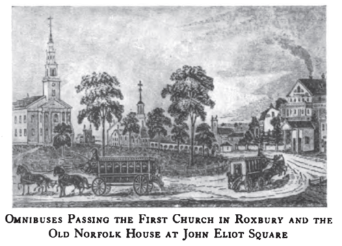
But by the mid-1820s, commerce between Boston and the surrounding cities and towns started to grow.  In 1826 or 1827, stage coach services connecting Boston with Roxbury, Charlestown, and East Cambridge appeared.  The Roxbury line terminated at the original Norfolk House, which was built in 1825.  These services were small, enclosed horse cars with benches facing forwards, like those pictured in most westerns.  This was not an optimal layout for passengers to get in and out frequently, they couldn’t carry many passengers, and they ran only hourly.  But they were a start.

By 1833, a man named Horace King, who had been employed as a waiter and general utility man at the Norfolk House for several years and had been saving his pennies, saw an opportunity to improve service.  He bought two vehicles, one of which was named the “Governor Brooks,” laid them out with the seats running along the sides facing each other and a door at each end of the car to make it easy to get in and out, and started the first omnibus service in Boston, from Norfolk House to the ferry at the foot of Hanover Street.  The round trip was 2 and 1/2 hours and the fare was 12 1/2 cents.

These first omnibuses were drawn by 4 horses with room for 24 passengers, 18 inside and 6 outside.  He experimented with various sizes of coach, from small 2-horse, 12-passenger affairs to massive 6-horse jobs that carried over 40 passengers, over the years.  There’s a marvelous children’s book called “Marco and Paul’s Voyages & Travels: Boston" that tells the story of two young men traveling from New York to Boston.  In it, young Marco sees his first Roxbury omnibus:

Paul goes on to explain that the larger omnibuses were something of an express route from Roxbury to downtown.  The smaller omnibuses were used on local routes, since the frequent stops and starts on a local route with a larger, heavier vehicle tired the horses out too quickly.

Within a few years King had control of almost all of the omnibus lines into the city and had over 250 horses and 150 men working for him.  He eventually bought and enlarged the Norfolk House and became incredibly successful, only to lose everything in the financial panic of 1856.  He moved home to Rutland and spent his last 40 years there in relative penury, eventually dying at the ripe old age of 96 in 1903.  To read more of his story, click on this link.

The next mode of transit to connect Roxbury to Boston was the steam railroad.  The Boston and Providence Railroad had started construction in 1832, and the spur to Dedham opened in 1834.  The Dedham spur followed the Stony Brook valley through Roxbury and had a stop at Roxbury Crossing.  But the train was less convenient and more expensive than the omnibus so it never really competed on the Roxbury Crossing stop, doing more to serve passengers coming in from farther away.

A view of the old Roxbury Crossing Station, with some of the first electric streetcars, just after the turn of the last century.

Between the omnibus service to various points in Roxbury and the train service, Roxbury’s population finally started growing.  In 1800, the town had a population of about 2700.  Thirty years later, after the coach service had started but before the omnibus and train were in operation, it was over 5200.  In the next 10 years, it grew to just over 9,000.  By 1850 it had doubled to over 18,000, with the vast majority of people riding omnibuses when they wanted to visit Boston or travel to Dorchester, Cambridge, West Roxbury, JP, or other suburbs.  

With the rapid growth in metro Boston, it was only a matter of time until a more efficient method of moving people from point to point became a necessity.  In 1856 that method finally arrived, in the form of the street railway system that had been pioneered in New York starting in 1852.  The first street railway system in Boston ran to Cambridge on March 26, 1856, followed in September by the Metropolitan railway company’s original line from Guild Row in Dudley Square to Scollay Square.

The street railway operators were private, for-profit operations that received charters from the state legislature to build their tracks on city streets.  The railway cars were drawn by horses and quickly settled into 4 major companies that each had a monopoly over its service territory, with the Metropolitan railway having the largest territory, serving East Boston, the Back Bay, Roxbury, Dorchester, Milton, JP, and Brookline.  

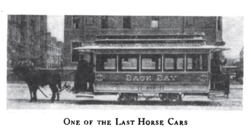
The first street railways weren’t necessarily popular with everyone.  Because they paved the area between the tracks, which was the only paved area in the street, people preferred to walk between the tracks.  Of course, this meant that they constantly had to move when the trains came, and for a brief time there was the complaint of “too many trains” from the pedestrian population. In Cambridge, the railway company’s opponents tore the tracks out of the street in the middle of the night on several occasions.  But before long the horse-drawn railroads gained acceptance, although the omnibus didn’t completely fade away for another 50 years.

The consolidation of the competition into 4 monopolistic lines eventually led to a decline in service, and by 1872 there were loud cries for more competition.  Among those demanding better service was our neighborhood’s own William Lloyd Garrison, who used his well-practiced sense of outrage.  In a letter from February of 1872 he bemoaned the situation to James Ritchie, a notable Roxbury resident and a man who was at the time one of the principal assessors for the city of Boston: “[The Metropolitan Railway Company] takes undue advantage of our Highland residents by inexcusably compelling them to be packed in those cars, frequently three times, and usually twice, beyond the number of seats provided; outraging all sense of propriety, at times bordering on indecency, in the enforced crowding together in a standing position of virtuous and refined ladies with coarse and vulgar men,—an exposure most trying not only to female delicacy, but highly favorable to the operations of pickpockets of both sexes.”

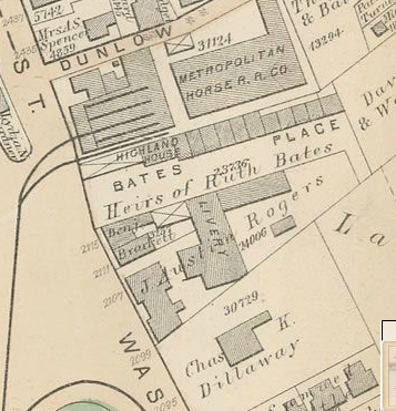
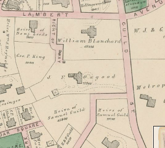
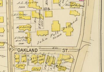
The 1873 map shows the Metropolitan horse barn at Eliot Square

Garrison and other residents were successful in getting more competition on the horse railways, and beginning in 1872 the Highland Railway company operated a service on the same lines that was widely regarded to be superior to the Metropolitan.  Of course, the arrangement meant that the Highland and other competing lines were using some of the tracks laid by the original railway companies, which were bitterly upset by this turn of events.  There were notable battles between the various companies, especially at the more popular spots where operators would jostle to become the first car in line, and if they lost out they would run the car as slowly as possible to try to become the first car at the next big stop.

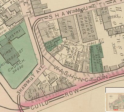
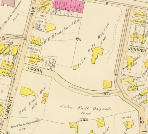
The same 1873 map shows the Highland Street Railway barn in Dudley behind Guild Row.  The Highland’s tracks ran up Shawmut, the Metropolitan’s up Washington.

In 1887, a businessman named Henry Whitney bought a huge tract of land in Brookline and commissioned Frederick Law Olmsted to lay out Beacon Street as a grand boulevard.  He laid railway tracks down this new street and formed his own railway company, the West End Street Railway Company, to shuttle people back and forth to his new subdivision.  The venture was a huge success, but the state of the other railway companies was so dismal that Whitney decided to take ownership of them so that his customers could get to their new homes more efficiently.  Amazingly, he was able to buy almost all of the old companies within the course of a year, and by the end of 1887 the West End Railway had 10,000 horses and all of the major street railways in Boston under its control.

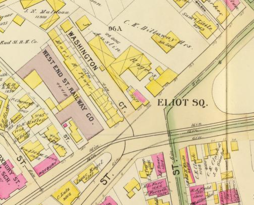
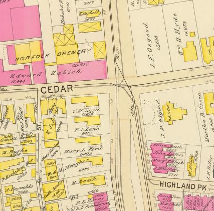
The West End Railway horse barn in Eliot Square, at the same location as the Metropolitan barn shown above in the 1873 map.  The company had a larger barn on the site of the current MBTA bus yard at Bartlett Street and another one roughly on the site of today’s Jackson Square T stop.

Before long, the West End railway was working on plans to electrify the system and remove the need for thousands of horses to haul passengers.  Within 20 years, the era of horse-drawn transit in Boston was over.  

If you’re interested in finding out more about the rapid changes in rapid transit, there are plenty of good sources that detail Roxbury’s role:

From Coach and Omnibus to Electric Car

Bacon’s Dictionary of Boston: Street Railroads

The Street Railway System of Metropolitan Boston

Moving the Masses: Urban Public Transit in New York, Boston, and Philadelphia 1880-1912

William Lloyd Garrison’s letter to James Ritchie

Streetcar Suburbs: The Process of Growth in Boston 1870-1900

JPHS - Jamaica Plain Streetcars, a History

2010 Boston Census data mapped! by Jason Turgeon

Via the JP Gazette, I bring you the myNeighborhood Census Viewer, a fantastic new mapping application from the City of Boston.  It’s a simple way to get info about any census block or group of census blocks in the city.  Simply click on any area and you’ll see the census block highlighted, with all of the stats that the census collects on race, gender, age, household status, etc., displayed right there.  You can also select multiple blocks through a variety of tools.  It’s also a beautiful basemap with building footprints.  Perfect for the armchair sociologist, historian, or cartographer!

Here’s a view of the info for my census block.

Image and New Development: Highland Park by Jason Turgeon

Here’s a link to a graduate thesis for the Harvard School of Design written by Master’s candidate Anne Burns in 1988.  The thesis, while clearly a scholarly exercise, presents a great overview of the issues that were facing Roxbury and Highland Park nearly 25 years ago.  It should be required reading for anyone who wants to discuss redevelopment in the area today, especially for the redevelopments scheduled at Bartlett Yard and Jackson Square.

The thesis starts out with her reasons for choosing Highland Park as a subject area, a brief but well-done history, and then jumps right into some of the issues the neighborhood was facing in the mid-80s. In some ways, things couldn’t be more different, and in others they haven’t changed at all.

The biggest difference is that at the time, a huge proportion of Highland Park was still distressed but there was finally a significant amount of renovation happening.  While we still have a handful of vacant buildings and there are many occupied buildings that could use a little sprucing up, I think it’s fair to say that the neighborhood has long since recovered from the worst of the population decline of the late 60s and early 70s.

The similarities are perhaps more striking.  Ms. Burns notes that residents of the neighborhood tend to have a much higher opinion of the area than outsiders.  She notes that despite this, people who do not live here were in charge of decisions that would have huge impacts on those who did.  And she discusses some of the reasons for this from an architectural point of view, discussing the way our community presented itself to the outside world from those places that the outside world would most likely see it:  along Columbus Avenue, Washington Streeet, from Roxbury Crossing and Jackson Square T stations, and along Malcolm X Boulevard.

She also notes that the residents were cautiously optimistic about the amount of redevelopment and new development taking place at the time.  They wanted something that felt unified, cohesive, and well-planned.  They feared piecemeal development that didn’t fit the character of the neighborhood, such as large public housing towers being dropped onto sites right next to one and two-family houses. They also wanted to maintain and celebrate our neighborhood’s many historical sites.  Hopefully all of this sounds familiar to those of us who are engaged in shaping Highland Park today.

After the discussion of why and how she will look at the neighborhood for redevelopment, the thesis dives into a GIS exercise.  Given the primitive nature of GIS software at the time, this is a pretty impressive undertaking, with page after page of detailed maps showing historic buildings, rowhouses, institutional structures, primary and secondary roads and traffic patterns, and vacant land.

She notes historic areas and viewpoints, and denotes the “spheres of influence” of the First Church and the Standpipe.  After all of this, she makes a development proposal focusing on new development in 5 key areas: the area where the mosque now sits, the area around the corner of Shawmut and Malcolm X, the Bartlett Yards area, the cluster of vacant lots around Thornton and Valentine, and the empty space along Columbus (including the RCC parking lots).

She takes great care to propose developments that will unify the neighborhood, siting larger institutional uses as a “hard edge” along Columbus and preferring residential-scale 1-3 families on Washington and in the Thornton Street parcel.  I won’t go into full detail here, but it’s a fascinating read and many of her analyses and decisions still hold up almost 25 years later.  

Sadly, many of these parcels are still vacant, but as we continue to discuss what should go where, I’d suggest taking a fresh look at this document. There is a lot we could bring into the current planning process.

by Jason Turgeon

Via the Highland Park neighborhood website, here’s a wonderful bird’s-eye view of the Boston Highlands in 1888.  Click through to see a version you can zoom in on.

Via the Highland Park neighborhood website, here’s a wonderful bird’s-eye view of the Boston Highlands in 1888.  Click through to see a version you can zoom in on.

1832 Map of Roxbury by Jason Turgeon

This gorgeous hand-drawn map of Roxbury from 1832 shows what the town looked like back when Roxbury was still largely a rural town with just a few thousand inhabitants and lots of farmland. 

Find the original on the JP Historical Society website at this link.

The Stony Brook by Jason Turgeon

Many people don’t know it, but there was once a brook running from JP along what is now Columbus Avenue and into the area around Forsyth Street on Northeastern’s campus.  The Stony Brook, commemorated in the Orange Line stop of that name, was the source of water for many of the breweries along Pynchon Street.  It was also the source of much misery in Roxbury and Boston due to its frequent floods.  Over time, it was eventually culverted almost entirely, and now it runs underground in a pipe for the majority of its length.  

There is an excellent history of the Stony Brook in blog form at http://stonybrookinboston.blogspot.com/.  Start with the oldest post and read in reverse order.

There is also a very good view of the Stony Brook in this 1832 map of Roxbury from the JP Historical Society.

Fort Hill with Standpipe, BPL photo by Jason Turgeon

I love this old, undated photo of the standpipe.  It’s got lousy composition, cuts off the top of the tower, has some smears of water or something all over it…but it’s so evocative.  Oh, and it appears to have been taken right outside or across the street from my front door.

The date’s hard to guess at, but the path to the left would not have existed in 1895, when the ward map shows a building from the St. Elizabeth Hospital in that location.  It might have existed in 1915, when the ward map shows that the hospital was gone and there was then a playground on the space, but it’s hard to say.

1873 Ward Map P on Wardmaps.com by Jason Turgeon

The map to the North(ish) of Map M. Bounded by Hawthorne/Ellis and Fort Ave (south), Centre (west), Dudley & Bartlett (north), Shawmut Ave (east).  Note that Shawmut Ave is now Washington St.

Of note:  Metropolitan Rail Road Co, now the closed MBTA Bartlett Bus Yard, someday to be redeveloped.  Cedar Square.  The estate of N.J. Bradlee.  The home of Edward E. Hale.  Norfolk House.  Estate of Alvah Kittredge.  Lewis Park, now renamed Kittredge Square.

1873 Ward Map M on wardmaps.com by Jason Turgeon

From School Street in Egleston Square (south) to Fort Ave (north) and from about Lamartine and Parker (west) to Washington St (east), covers Highland Park proper.  At the time, Washington St. was called Shawmut Avenue; Columbus Ave. was called Pynchon St.

Of note:  the Stony Brook, in its above-ground form.  The Roxbury Almshouse, on what is now Marcella Park.  The NE Gard Factory (what’s a gard?) on Vale St., later to become the Dennison tag factory (subject of a future post).  The SC Thwing Estate on Thwing St.  The Highland Park Standpipe, completed in 1868 to provide high service water to Roxbury Highlands.